 Catalogue PIGMA
/Physical oceanography/Currents
Type of resources
Available actions
Topics
Keywords
Contact for the resource
Provided by
Years
Formats
Representation types
Update frequencies
status
Scale
-
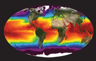
NASA's Physical Oceanography Distributed Active Archive Center (PO.DAAC) is located at NASA's Jet Propulsion Laboratory in Pasadena, California. PO.DAAC manages and provides tools and services for NASA's oceanographic and hydrologic data (satellite, airborne, and in-situ) to enable a greater understanding of the physical processes and conditions of the global ocean. Measurements include gravity, ocean winds, sea surface temperature, ocean surface topography, sea surface salinity, and circulation. The data support a wide range of applications including climate research, weather prediction, resource management, policy, and the stewardship of ocean data resources.
-
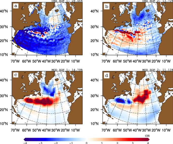
The gyre index constructed here from satellite altimetry is related to core aspects of the North Atlantic subpolar gyre, meridional overturning circulation, hydrographic properties in the Atlantic inflows toward the Arctic, and in marine ecosystems in the northeast Atlantic Ocean. The data series spans the period January 1993 to September 2018. Data description: Monthly gyre index from January 1993 until September 2018. The data is provided in one comma separated value (csv) file with the following entries on each row: year, month, index value. The index is normalized, i.e. it has a zero mean and unit standard deviation. Positive (negative) gyre index reflects stronger (weaker) than average surface circulation of the North Atlantic subpolar gyre.
-

The European Marine Observation and Data Network (EMODnet) is a long-term, marine-data initiative funded by the European Maritime and Fisheries Fund which, together with the Copernicus space programme and the Data Collection Framework for fisheries, implements the EU’s Marine Knowledge 2020 strategy. EMODnet Physics (www.emodnet-physics.eu) is one of the seven domain-specific portals of the European Marine Observation and Data Network (EMODnet). EMODnet-Physics map portal (www.emodnet-physics.eu/map) provides a single point of access to validated in situ datasets, products and their physical parameter metadata of European Seas and global oceans. More specifically, time series and datasets are made available, as recorded by fixed platforms (moorings, tide gauges, HF radars, etc.), moving platforms (ARGO, Lagrangian buoys, ferryboxes, etc.) and repeated observations (CTDs, etc.). The available themes are the temperature of the water column, the salinity of the water column, horizontal velocity of the water column, sea level and sea level trends, wave height and period, wind and atmospheric pressure, optical properties (e.g. light attenuation, back scattering, turbidity, etc.), underwater sound pressure level (acoustic pollution), river runoff, other biogeochemical data (e.g. chlorophyll, dissolved oxygen, etc.), sea-ice coverage. Acquisition of these physical parameters is largely an automated process based on a “federated” network infrastructure linking data providers and other marine data aggregating infrastructure. In particular, EMODnet Physics is strongly federated with two other European data aggregating infrastructures. One is the Copernicus Marine Environment Monitoring Service - In Situ Thematic Assembly Centre for operational data flow, while historical validated datasets are organised in collaboration with SeaDataNet and its network of National Oceanographic Data Centres. The NRT data go through a stricter quality control before NODCs validate the datasets for long-term storage and stewardship. This validation process ends when the metadata of the processed dataset are published in a CDI (Common Data Index). CMEMS-INSTAC and SDN-NODC subsets are integrated with other available sources to make the most comprehensive physical parameter data catalogues available. Thanks to international collaborative relationships to provide data access to – and preview for – coastal data in non-European areas (e.g. NOAA platforms for the US, IAPB platforms for the Arctic area, IMOS for Australia and others), EMODnet Physics catalogues are going beyond European borders to offer an even more exhaustive entry point to global-ocean physical observations.
-
The Joint WMO-IOC Technical Commission for Oceanography and Marine Meteorology Observing Programmes Support Centre, provides technical coordination at international level for the sustained elements of the Global Ocean Observing System. The Centre monitors in real-time the status of the observing networks and provides a toolbox to evaluate their performance and optimize their implementation and data flow. Currently OceanOPS monitors the Argo profiling floats, the DBCP surface drifters, coastal and tropical moorings, ice buoys, tsunami buoys, the OceanSITES moorings time-series, the GO-SHIP hydrographic reference lines, the SOT mat/ocean ship based observations and the GLOSS sea level tide gauges. A number of other observing systems are being added gradually, including ocean gliders, polar systems, marine mammals and potentially HF radars.
-

Data and imagery from the Atlantic basin: - Climate - Cloud Profiling Radars - Air-Sea & Air-Land Fluxes - Wind Profiling Radars - Satellite - Local Weather and Climate PSL archives a wide range of data ranging from gridded climate datasets extending hundreds of years to real-time wind profiler data at a single location. The data or products derived from this data, organized by type, are available to scientists and the general public at the links in the website. The third-party data appearing on this web site may be reformatted from their original form, but not altered as to the informational content contained therein. It is provided as a public service. Further, this data does not reflect an official view or position of NOAA.
-

Several climate indices, regarding Atlantic Basin: - North Atlantic Oscillation - Southern Oscillation Index - Bivariate ENSO Timeseries - Tropical Northern Atlantic Index - Tropical Southern Atlantic Index - Oceanic Niño Index - Multivariate ENSO Index (MEI V2) - North Tropical Atlantic SST Index - ENSO precipitation index - Northeast Brazil Rainfall Anomaly - Solar Flux (10.7cm) - Global Mean Lan/Ocean Temperature
-
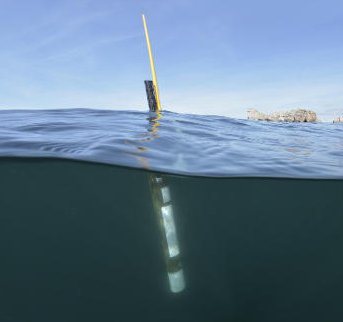
Argo is a global array of 3,000 free-drifting profiling floats that measures the temperature and salinity of the upper 2000 m of the ocean. This allows, for the first time, continuous monitoring of the temperature, salinity, and velocity of the upper ocean, with all data being relayed and made publicly available within hours after collection. The array provides 100,000 temperature/salinity profiles and velocity measurements per year distributed over the global oceans at an average of 3-degree spacing. Some floats provide additional bio-geo parameters such as oxygen or chlorophyll. All data collected by Argo floats are publically available in near real-time via the Global Data Assembly Centers (GDACs) in Brest (France) and Monterey (California) after an automated quality control (QC), and in scientifically quality controlled form, delayed mode data, via the GDACs within six months of collection.